East-west road is meant to facilitate movement of troops and logistical support
ByDavid S. Cloud, and Dov Lieber, WSJ Feb. 20, 2024
United Nations doctors were allowed to enter Nasser hospital in Khan Younis after the Israeli military raided the facility. Israel said it had intelligence indicating that hostages kidnapped by Hamas were held there but none were found during the raid. Photo: The World Health Organization
TEL AVIV—The Israeli army is expanding a road across central Gaza to facilitate its military operations, part of its plans to maintain security control over the enclave for some time, according to defense officials.
The gravel-paved road is one of a number of Israeli efforts to reshape the topography of the Gaza Strip—and give its military freedom of movement and a tighter grasp on the territory that was the launchpad for the Oct. 7 attack that killed about 1,200 people in southern Israel and sparked the current conflict.
The corridor south of Gaza City, stretching roughly 5 miles from the Israeli border to the coast, divides Gaza in two, along an east-west strip of land occupied by Israeli troops since early in the four-month-old war.
This will allow Israel’s military to continue to move quickly across the enclave along a secure route, even after most troops pull out. The Israeli military already controls major north-south roads in Gaza.
The road forms part of an emerging picture of how the Israeli army is preparing for the next stage of war, when it plans to withdraw from populated areas and concentrate on targeted raids against Hamas, a U.S.-designated terrorist group.
The building and expansion of the road comes as the Israeli military is also building a roughly 1-kilometer buffer zone just inside Gaza’s border with Israel, where Palestinians would be barred from entry.
U.S. officials have warned Israel repeatedly against altering Gaza’s borders or carving up its territory. They have publicly voiced opposition to the creation of a buffer zone.
The east-west route is intended to be used and patrolled until Israeli military operations in Gaza are complete, which could last months or even years, according to Israeli officials, who say they have no intention to permanently occupy Gaza but plan to maintain “security control” within its borders for an indefinite period. In the wake of the Oct. 7 attack, Israel pledged to eradicate the threat of Hamas from Gaza.
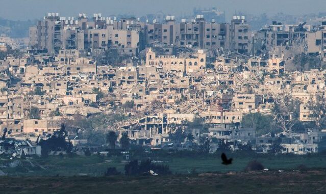
Damaged buildings in central Gaza on Tuesday as the conflict between Israel and Hamas continued. PHOTO: SUSANA VERA/REUTERS
The revamped road also could effectively create a militarized belt across Gaza that could aid in preventing the return of about one million Gazans who fled to the south amid Israeli bombardment and calls for evacuations in the early months of the war, according to analysts. The route will be guarded by Israeli troops to prevent militant attacks, one of the military officials said.
Israeli officials have said they don’t intend to let displaced Gazans return at least until military operations are complete in the north and a deal is reached to return the estimated 130 hostages and dead Israelis kidnapped by Hamas on Oct. 7.
“I’d call it long-term temporary—certainly for all of 2024,” Miri Eisin, a retired colonel in the Israeli Army, said of how long Israel intended to use the east-west corridor.
Israeli combat engineers are planning to destroy houses and other structures along the road’s flanks and are already laying a new base of gravel to widen the corridor and make it more useful to the military, according to footage aired Saturday on Israel’s Channel 14. A military spokesman declined to comment on the report.
Satellite photos from February provided to The Wall Street Journal by Maxar Technologies, a Colorado-based satellite operator, shows what appears to be a winding dirt road bisecting Gaza, through farms and lightly populated areas. It parallels an existing paved east-west road a little further north, the photos show.
Jacob Nagel, a former Israeli national-security adviser, said the road would create a clear divide between northern Gaza and the rest of the enclave. He said it was unlikely any wall would go up adjacent to the road, but added it could have different north-south crossing points that would be guarded.
“I think it’s mostly symbolic to differentiate between the north and south,” said Nagel, a senior fellow at the Foundation for Defense of Democracies.
Israel has already shifted in northern Gaza to what it is calling the third phase of the war, in which large troop movements are replaced with more targeted raids. The first stage was the aerial bombardment of Gaza in the first weeks, followed by the ground invasion that is still under way in the south.
Israeli officials estimate that 150,000 to 200,000 Gazans are still living in Gaza City, which had a prewar population of 1.2 million.
Write to David S. Cloud at david.cloud@wsj.com and Dov Lieber at dov.lieber@wsj.com


Leave a Reply
You must be logged in to post a comment.